–By Chelsey Stone–
This the first installment of a two-part cross-country road trip series. Check out part two here.
—
My husband, Patrick, is in the military, so moving across the country is a regular part of our lives. Our most recent move was from San Diego, California, to Washington, D.C. from July 10 to July 21, 2024. Our experience is unique compared to most other travelers, in that we don’t need to plan a return trip.
When planning ahead for our latest cross- country road trip, we decided to see as many national parks as we could — preferably stopping to camp. Our plan’s biggest obstacle was the timing, hitting the road right in the middle of summer. We had to scour to see when the National Parks Service released any last-minute campsites, requesting a notification when campsites became available. As we discovered at Rocky Mountain National Park, camping exempts you from timed-entry restrictions. When we did stay in hotels, we used points Patrick had earned from work travel.
A few other unique points of our trip: We’re both runners, so we jogged three to 10 miles on the trails we visited. Because Patrick is close to retirement, we made it a point to visit towns we might enjoy living in — a win-win, with each spot already on the itinerary but doubling as a trial for what the future could hold.
It was quite the journey, so let’s jump right into our 10-day, coast-to-coast cross-country road trip:
Day One
Start: San Diego, California
End: Prescott, Arizona
Drive time: 7 hours
Stay: Potato Patch Campground
—
San Diego, California
Before setting out, I suggest fueling up at the Better Buzz drive-thru. I ordered a Conscious Chocolate smoothie but asked to substitute banana with avocado. We learned my request had caused quite a stir inside.
It’s about seven hours from San Diego to Potato Patch Campground in Prescott, Arizona. Familiar with the drive through Arizona, we made few stops that day (a bathroom break and one last break to snag some In-N-Out burger). With an hour of remaining sunlight when we arrived at the campground, we discovered one of our REI Half Dome tent poles was broken while setting up.
Tip: If you’re camping for several days, put your tent together before you leave to check for issues like this one.
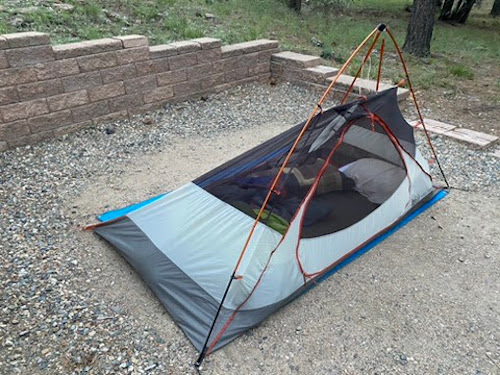
Chelsey and Patrick’s broken tent on night one at Potato Patch campground
Day Two
Start: Prescott, Arizona
End: Flagstaff, Arizona
Drive time: 7 hours
Stops: Jerome and Sedona, Arizona
Stay: Bonito Campground
—
Potato Patch Campground
In the morning, we ran Woodchute Trail (here’s our route on Strava). Trail #531 was accessible right from our campsite, which we followed for about 0.9 miles until we got to Woodchute Trail #102. After four miles, we reached a meadow at 7,600 feet of elevation and enjoyed a spectacular view of Jerome, Arizona, one of our many destinations that day.
Tip: For long camping trips where showers aren’t always an option, I highly recommend bringing along body wipes. We tried Klean Freak but liked Hustle Clean from REI best. It was remarkable how clean we felt after our runs—even after multiple sunscreen applications.
Prescott, Arizona
We met with friends who live in the area for breakfast at The Porch in Prescott and had coffee, a breakfast sandwich, and the quiche of the day. The café is enormous, light, and airy inside. A large fan in the back corner was blowing the already sunbaked morning air.
Tip: Take advantage of stops like these to charge your devices and use the Wi-Fi while you have the access.
From The Porch, we drove to Whiskey Row — it’s only 0.2 miles down the road if you’d rather stretch your legs, but you can also walk around Courthouse Plaza — and through downtown before stopping at the Frontier Village Center REI. We couldn’t replace our tent pole, but our friends suggested we try an outdoor equipment consignment store in Flagstaff, our final destination for the day.
Prescott to Flagstaff is about a 90 minute drive, but we decided to stop by Jerome and Sedona before retiring at Bonito Campground for the night.

A pit stop at The Porch in Prescott, Arizona
Jerome, Arizona
From Prescott, we backtracked over Mingus Mountain to Jerome. Patrick deftly parallel parked the car on a slope just past Jerome’s main street, and we walked back toward the town.
We stopped into Miner’s Pick Rock Shop, and as soon as we expressed the slightest curiosity about the collection, the staff person told us all about the different minerals and gemstones. She was a self-proclaimed second generation rock hound (a term I’d never heard before). Her father liked Jerome so much after visiting that he relocated his family to the town from Atlantic City (though he would return to New Jersey to work and bring back money). As she recounted the tale, she said her father’s passion rubbed off on her and her sister.
Nearby is Nellie Bly Kaleidoscopes, filled with all types of kaleidoscopes. I couldn’t believe the variety and complexity of some of the shifting colors within.
On our drive out, we stopped at an overlook across from Jerome to take in the town. Interpretive signage explained how, at its peak, there were 15,000 people living in the town, but now there are just 500.
Tip: There was plenty more history to explore in Jerome for those interested in old Western mining towns. Ghost enthusiasts and lovers of the supernatural should visit the Jerome Grand Hotel, a former hospital said to be haunted.
Sedona, Arizona
As we got closer to Sedona, massive red rock formations came into view and served as the backdrop throughout our visit (the aptly named Red Rock State Park is right off the drive from Jerome).
Our first stop was the Chapel of the Holy Cross. From the uppermost parking spaces, we made our way up the winding walkway to a tall, narrow church built into red rock buttes in 1956. Within the church is a sculpture of Christ crucified on the Tree of Life and paintings in frames containing railroad spikes that seemed to be arranged like Roman numerals (maybe a biblical reference I didn’t know), all of which we admired from the back pew. There is also a cramped but plentiful gift shop downstairs.
We made our way downtown and parked just off the main street in a free public parking lot. Touchstone Gallery lured us in with a neon sign that said “Real Dino Fossils.” It was like a high-end version of the gem store in Jerome. There were indeed fossils, as well as very large — and very expensive — minerals and gems, some carved into dishes or tables. We then picked up several postcards at Cactus Carlos (the 270 N State Rte. location).
From Sedona, we continued our drive on a windy, tree-lined road through red rocks.
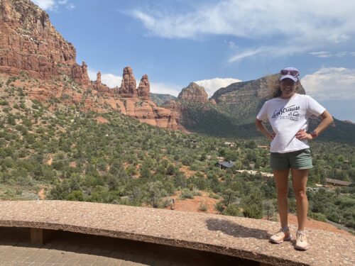
The view from Chapel of the Holy Cross in Sedona, Arizona
Flagstaff, Arizona
In Flagstaff, Snow Mountain River had a used deluxe model of our tent, very reasonably priced.
Tip: If you find yourself in need of camping gear, I highly recommend stopping here. The used gear was in great shape, and the staff were helpful and knowledgeable.
Before going to our campsite, we stopped at Walmart to pick up sandwich supplies (along with free mini packs of mayo and mustard from the deli counter).
Our home for the night was 18 miles northeast of Flagstaff at Bonito Campground, just outside Sunset Crater National Monument and Wupatki National Monument. Our snazzy new tent erected, we ate sandwiches inside to avoid the bugs. Nearly all our fellow campers were in RVs, so we had the bathroom next to our campsite to ourselves.
Day Three
Start: Flagstaff, Arizona
End: Durango, Colorado
Drive time: 5 hours
Stops: Petrified Forest National Park, Arizona
Stay: Fairfield Inn & Suites Durango
—
Bonito Campground
Patrick knew of nearby Mount Elden Trailhead from his interest in ultra running. We “ran” nearly three miles up Elden Lookout Trail and gained 2,205 feet of elevation along the way (Elden Mountain Strava route). The first mile or so wasn’t too challenging, but the second mile had us climbing 1,014 feet. We were rewarded with an expansive view above Flagstaff at the 2,300-foot summit.
The lookout building at the top is not open to the public, as far as we could tell. We passed through several landscapes on our way up: pinyon-juniper woodland, ponderosa pine forest, and mixed conifers. The 5.6 mile journey took us two hours; as a warning, this route is not for the faint of heart.
Back at the car, we wiped off. At this point, we’d gone two days without a shower, completed two trail runs, and applied tons of sunscreen. Yet, we felt pretty clean as we set off to downtown Flagstaff.
I needed to submit some work to a client, so I used the Wi-Fi at Firecreek Coffee Company (the Flagstaff location) while we enjoyed some coffee and scones. There was a cozy space at the front of the café, but tucked away past the bathrooms, I saw what looked like a music venue with a wide-open area and stage. We sat back at some tall tables with booth seating for a few hours as I worked before heading to Petrified Forest National Park.
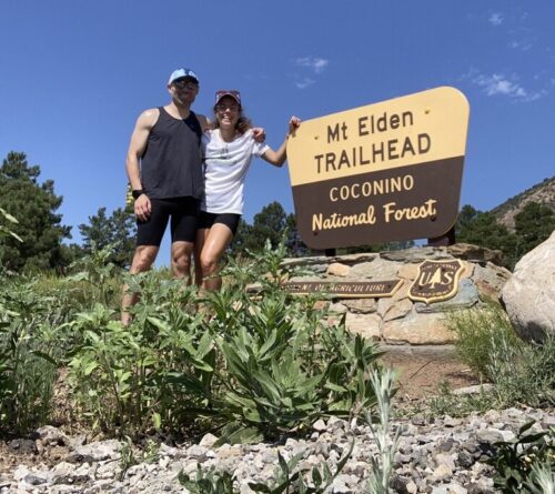
Chelsey and Patrick at the Mount Elden trailhead
Petrified Forest National Park
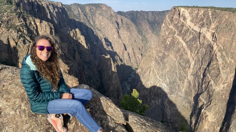
We entered the park at the south entrance via US-180 E. The park’s main attractions are the petrified pieces of wood from 200-million-year-old trees with the Painted Desert landscape as a backdrop. During the middle of a hot weekday, there weren’t many people on the road or at the stops we made. In fact, we had the Blue Mesa trail to ourselves for almost the entire walk.
The Rainbow Forest Museum was not far from the entrance and had numerous displays describing the history of the park, like how it had once been near the equator before being moved by tectonic forces. Behind the visitor’s center, you can take a self-guided tour of the Giant Logs 0.4-mile loop.
There was a plaque commemorating Stephen Tyng Mather, the first director of the National Park Service, and variously sized petrified logs, including the enormous Old Faithful (which was glued together after being struck by lightning in 1962). If you’re lucky, an amateur photographer might attempt to speed up your inept selfie taking (so they can get on with their photo shoot) and offer to take your photo. We skipped walking into the separate Rainbow Forest Gift Shop because we’d already bought souvenirs in the museum.
We traveled down Main Park Road to Agate Bridge — a 100-foot, partially exposed petrified log over a gully now supported by a concrete beam underneath. We then drove the Blue Mesa Scenic route to the one-mile Blue Mesa loop (short enough for kids to enjoy!), which was one of our favorite hikes of the entire trip. We descended a winding asphalt path to walk among beautifully colored mesas and fossilized wood. Even with taking our time, it only took us 24 minutes to walk the loop (Blue Mesa Strava route).
Our last stop before exiting the park via the north entrance off I-40 was Newspaper Rock. Standing high above it, you can get a closer look at its 650 petroglyphs left by Puebloans using viewing scopes.
That night, we stayed at the Fairfield Inn & Suites Durango, getting in late because we crossed into Mountain Daylight Time.
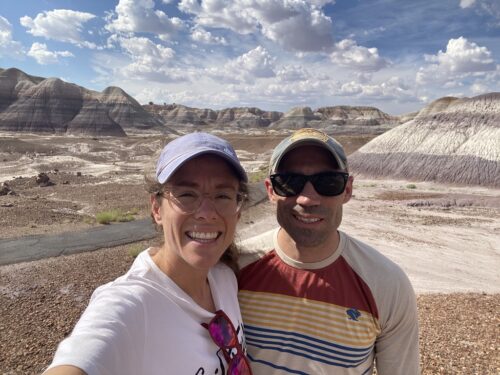
The favorite hike of the trip: Blue Mesa Loop at Petrified Forest National Park, Arizona
Day Four
Start: Durango, Colorado
End: Black Canyon of the Gunnison National Park, Colorado
Drive time: 3 hours
Stops: Silverton and Ouray, Colorado
Stay: South Rim Campground
—
My husband is interested in Colorado as a possible home, so this was a day to explore towns he knows of from ultra running as options to live in the future.
Durango, Colorado
With a milder climate than its neighboring mining towns, coal for smelting, and a good supply of water from the Animas River, the Denver & Rio Grande Railroad was established in 1880s Durango to support mining in nearby Silverton. The Durango & Silverton Narrow Gauge Railroad still operates today, only now its cargo includes tourists.
We parked along the Animas River and walked a bit of the river before crossing into the downtown area, watching kayakers navigate the waters along the way. We wandered down Main Avenue until we came to Second Story Books. There are some great areas to explore as you walk in, with sections focused on local history in Durango and Colorado as a whole, mining and ghost town lore, and Old West history. Upstairs features a small local authors’ section, alongside rooms with shelves upon shelves of books of all genres and topics.
We stopped for lunch at 11th Street Station, which was a very lively food truck park. So lively that we experienced quite the wait for our food, but we were distracted from our hunger by the live music nearby. The zucchini, filet mignon, and bacon cheeseburger sliders from Backcountry Gourmet were well worth the wait.
Silverton, Colorado
Prospectors discovered gold and silver in 1860 in the San Juan Mountains, but it wasn’t until 1874 that miners arrived en masse and Silverton was established. As the population grew, Green Street served as an imaginary border between the families that arrived and the burgeoning vice district. Mining operations didn’t stop until the early 1990s (though gold and silver deposits remain), but now the town has embraced its natural beauty, which thousands of annual visitors come to appreciate as well.
Eager to admire its beauty ourselves, we traveled from Durango to Silverton on Route US US 550 S. Exiting the highway, we drove down wide Green Street into Silverton, where multicolored, old-timey buildings boasted coffee or antiques. At the end of this main road, we parked in a cul-de-sac of museums and civic buildings next to Cement Creek. We happened to stop in during the Hardrock Hundred trail race, so we took advantage and headed to the finish line to chat with fellow spectators.
Then, we drove to Hillside Cemetery. It was only 0.7 miles from where we’d parked, but we still managed to make several wrong turns before arriving at a single lane, gravel road. We walked up the hillside to look at some very old tombstones before we hit the road again.
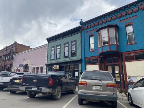
Silverton, Colorado
Ouray, Colorado
About 45 minutes further down on Route 550, our next stop was Ouray. In the 1870s, miners found gold in Ouray as well. Like the others, this was no ghost town but rather a thriving community, thanks to rebranding as the “Outdoor Recreation Capital of Colorado.”
We descended into the town and parked on yet another Main Street between 6th and 7th Streets. We looked around Ouray Books (perused another well-stocked local history section), as well as the Columbine Mineral Shop. There was a beautiful sandstone sculpture we were interested in, but when we attempted to haggle, the shopkeeper held firm.
Tip: City Hall and Walsh Library, on the National Registry of Historic Places, were closed, but we could still enter the building to use public restrooms.
Black Canyon of the Gunnison National Park: South Rim Campground and Rim Rock Trail
Montrose was our last stop for gas and sandwich fixings before arriving at South Rim Campground around 5:30 p.m. We set up camp and walked a quarter mile to Rim Rock Trail (Strava route).
The canyon views were incredible; we kept stopping to look because every quarter mile the view changed, from looking farther into the canyon to catching a glimpse of the river below. We chatted with someone passing through the park, stretching her legs on the trail, who said this was the most underrated park—and I couldn’t agree more.
It also has the advantage of being a much less frequented park: Around a half-million people visit Black Canyon of the Gunnison National Park each year, versus the 5 to 6 million who visit the Grand Canyon annually. I found the views as stunning as the Grand Canyon, just in a different way. We turned around at the visitor’s center (another great lookout point) about one mile out.
At 8:30 p.m., we gathered at the campground’s amphitheater with dozens of fellow campers to learn about the park’s wildlife’s night-time adaptations. The ranger, wonderfully engaging, compared the night vision of owls, mountain lions, and bats — which just so happened to be zig-zagging overhead. The kids in the audience listened with rapt attention and were eager to answer the questions the ranger posed.
Tip: Despite frequenting National Parks, this was our first ranger talk. If you haven’t gone to one before, I recommend it.
Day Five
Start: Black Canyon of the Gunnison National Park, Colorado
End: Rocky Mountain National Park, Colorado
Drive time: 5 hours
Stay: Timber Creek Campground
—
Black Canyon of the Gunnison National Park
We first drove to Painted Wall Overlook. Up to this point, we weren’t certain we’d seen the iconic canyon wall image on all the posters: a black canyon. From the overlook parking, we couldn’t yet see the canyon, blocked by some shrubs (which smelled wonderful), but we finally came to a point where the path cleared and caught sight of it. It was incredible. The canyon wall was indeed a dark black, in stark contrast to the rest of the canyon.
On the way to the visitor center, we stopped at Devil’s Lookout (yes, just for the name) and Cross Fissures Overlook. Right outside the visitor center (which has ample information about the rock formations for anyone looking to learn more), we caught the 1.5-mile Flat Oak Loop (Strava route), stopping frequently to admire the views as we’d done the night before.
We wiped off back at the car and got on the road for our five-hour drive to Rocky Mountain National Park.
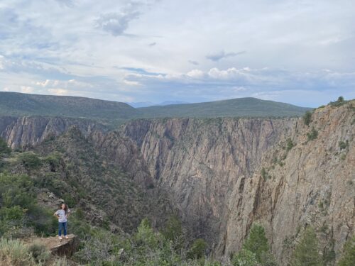
Black Canyon of the Gunnison National Park, Colorado
Rocky Mountain National Park: Timber Creek Campground and Colorado River Trailhead
After we set up camp at Rocky Mountain National Park Timber Creek Campground, we found a trail to explore: the Colorado River Trailhead (Strava route). Fortunately, there weren’t many cars on the road because we had to run on the narrow shoulder for the first two miles. Almost immediately after setting out, we saw a huge female elk in the valley next to the road. We also saw numerous herds before we arrived at the trail.
This wooded trail was beautiful and not too muddy despite recent rain, everything glistening in the last of the evening sun. We got to the Colorado River and then headed back to beat the dark.
The cross-country road trip is half over, but there’s plenty more in store. Check out the second part here!
—
 About the Author: Chelsey Stone is a freelance travel and health & fitness writer who’s written for National Geographic, Runner’s World, and Bicycling. She lives in the D.C. area and loves to use books and running as a means to explore the city and anywhere she travels to.
You can find her at chelseygrassfield.com or on Instagram @chelseygrassfield.